Explorar por categoría
Geología Experiencias AR
Explora experiencias AR públicas en Geología y abre las experiencias que te resulten interesantes.
Subcategorías
0
Experiencias
39
Experiencias
Abre cualquier experiencia interesante y mira cómo se usa este formato en la práctica.
rare
The Karst Landforms and Cycle of Erosion
Karst landforms are shaped by the dissolution of soluble rocks like limestone, gypsum, and dolomite. Common features include sinkholes, caves, and underground rivers. The karst cycle of erosion begins with water seeping into cracks, dissolving the rock, and expanding cavities over time. This process creates distinctive landscapes with collapsed surfaces and intricate cave systems. The cycle evolves from early surface erosion to mature underground drainage networks, and eventually, land collapse or landscape leveling.
Abrir experiencia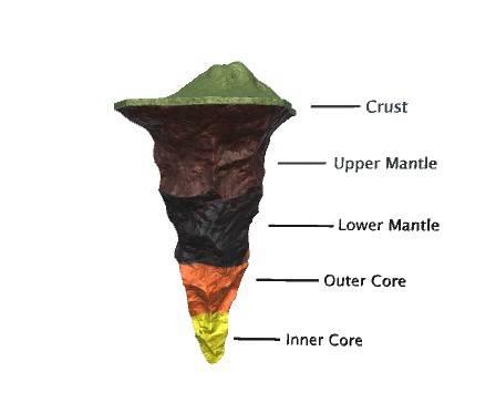
rare
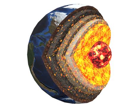
Layers Of The Earth
The Earth is composed of several layers: the crust, a thin outer layer; the mantle, a thick semi-solid layer beneath the crust; the outer core, a liquid layer of iron and nickel; and the inner core, a solid iron-nickel center. Each layer varies in composition, state, and temperature, contributing to Earth’s geology and magnetic field.
Abrir experiencia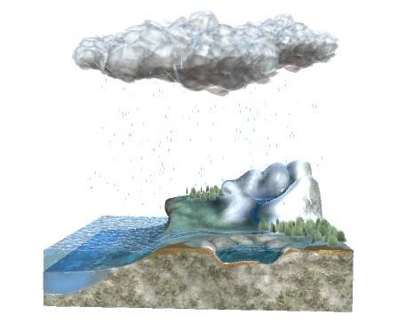
epic
Water (Hydrologic) Cycle
The water (hydrologic) cycle describes the continuous movement of water on, above, and below the Earth’s surface. It involves processes such as evaporation (water turning into vapor), condensation (vapor forming clouds), precipitation (rain, snow, etc.), and collection (water gathering in bodies like rivers, lakes, and oceans). This cycle is essential for distributing water, supporting life, and regulating climate.
Abrir experiencia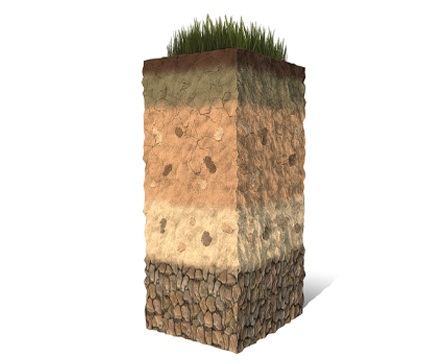
rare
Horizons
Horizons refer to distinct layers of soil that develop over time due to various soil-forming processes. These layers include the O Horizon, which is the topmost layer rich in organic material; the A Horizon, known as topsoil, containing organic material mixed with minerals; the E Horizon, a lighter leaching layer; the B Horizon, or subsoil, where minerals accumulate; the C Horizon, consisting of weathered parent material; and the R Horizon, which is unweathered bedrock. Each horizon has unique characteristics that influence soil properties and fertility.
Abrir experiencia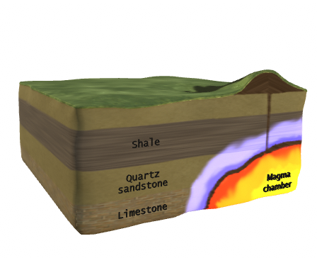
rare
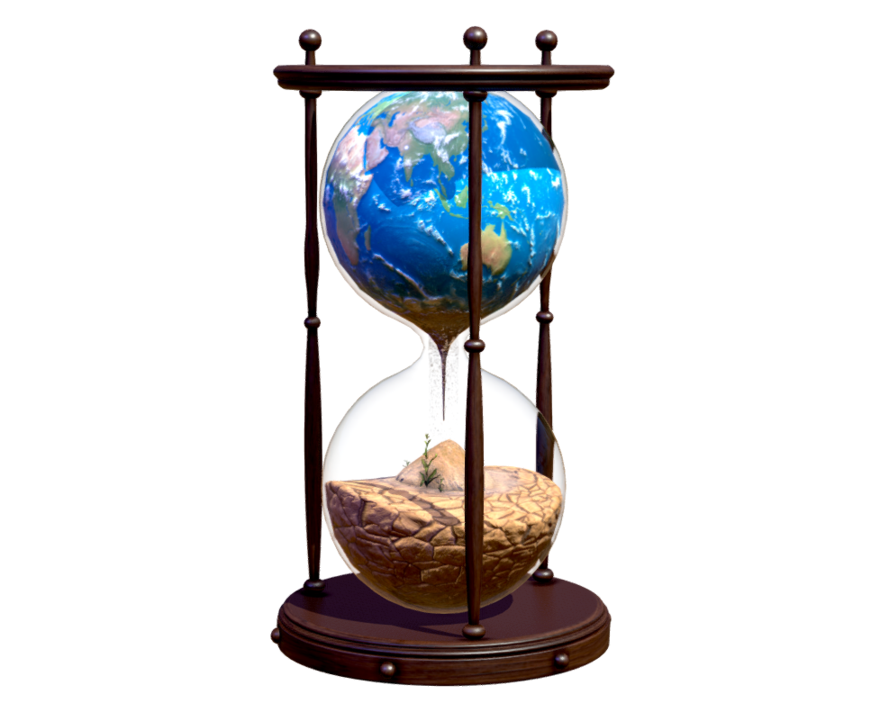
Pollution's Hourglass: Earth's Fragile Balance
“Pollution’s Hourglass: Earth’s Fragile Balance” is a poignant 3D model depicting the urgent environmental crisis. Symbolized by the iconic hourglass shape, in its upper chamber, the beauty of Earth flourishes, while the lower section starkly reveals the consequences of pollution. Through its compelling imagery and thought-provoking symbolism, this model sparks dialogue, raises awareness, and motivates individuals and communities to work together in safeguarding the precious balance of our planet.
Abrir experiencia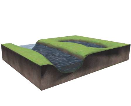
rare
Oxbow Lake
An oxbow lake is a U-shaped water body created when a river’s meander loop is cut off. This process occurs due to erosion and sedimentation in meandering rivers. Oxbow lakes are known for their calm and still waters, often found in flat or low-lying landscapes. These lakes offer diverse ecosystems and serve as habitats for various wildlife species. The term “oxbow” reflects their U-shaped resemblance, named after the curved collars once used for guiding oxen.
Abrir experiencia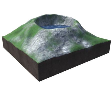
rare
Volcanic Lake
A volcanic lake is a body of water that occupies a crater or caldera formed by past volcanic activity. These lakes are often nestled within the rugged terrain of volcanic landscapes and can vary in size and depth. Volcanic lakes can be found in both dormant and active volcanic areas, and their unique geological settings often contribute to distinctive features such as hot springs, geothermal activity, and nutrient-rich soil, influencing the surrounding ecosystem. The water in volcanic lakes may also exhibit different characteristics due to dissolved minerals or gases originating from the volcanic activity.
Abrir experiencia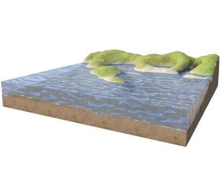
rare
Marine Depositional Landforms
Marine depositional landforms are natural features sculpted by the relentless forces of the sea. These formations, shaped by the interaction of water, sediments, and coastal dynamics, include sandy beaches, barrier islands, coastal dunes, and tidal flats. They not only showcase the dynamic beauty of coastal environments but also play a crucial role in shaping coastal ecosystems and protecting against erosion and storm surges.
Abrir experiencia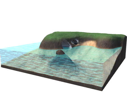
rare
Marine Erosional Landforms
Marine erosional landforms are captivating geological features sculpted by the relentless power of the sea. These formations, shaped over time by the erosive forces of waves, currents, and tides, include sea cliffs, sea caves, arches, and stacks. They bear witness to the ongoing transformation of our coastal landscapes, providing insights into the dynamic interplay between water and rock.
Abrir experiencia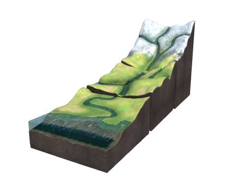
rare
River Systems And Fluvial Landforms
Fluvial systems, shaped by rivers and streams, are essential for both human civilization and ecosystems. They erode, transport sediment, and create landforms. Watersheds, with their main rivers and tributaries, are crucial in fluvial geomorphology, separated by divides where water flows in different directions. Headwater streams carve v-shaped valleys with waterfalls and rapids, while lower-elevation streams merge into broader valleys. Rivers meander across flat floodplains and may split into channels at their mouths, forming deltas. Coastal plains and deltas are created by river sediments.
Abrir experiencia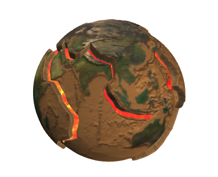
rare
Movement of Lithospheric Plates
The lithosphere is Earth's rigid outer layer consisting of the crust and upper mantle. It is divided into tectonic plates that constantly move. There are three types of plate boundaries: divergent (plates move apart), convergent (plates collide), and transform (plates slide past each other). These boundaries are hotspots for volcanic activity, earthquakes, and mountain formation. The Ring of Fire refers to the intense volcanic and seismic activity along the Pacific plate's edges.
Abrir experiencia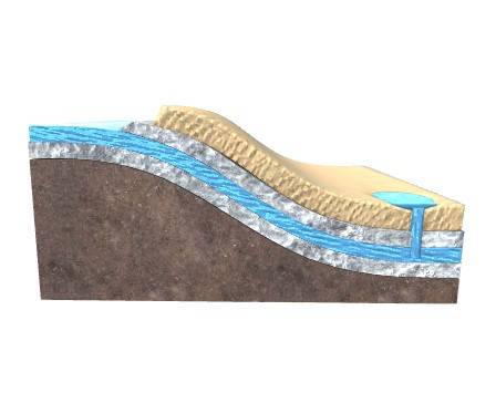
rare
Artesian Well
Artesian groundwater is the same as any other type of groundwater the only difference is how it gets to the surface. An artesian well is a well that brings groundwater to the surface without pumping because it is under pressure within a body of rock and/or sediment known as an aquifer.
Abrir experiencia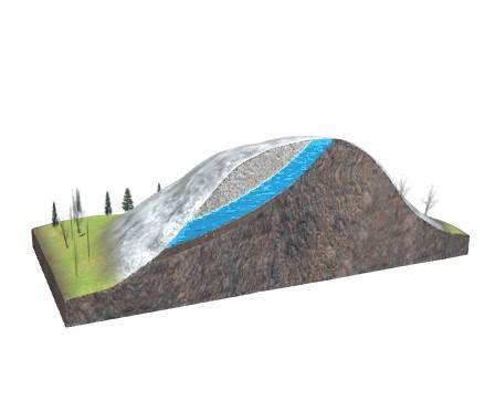
rare
Gravity Spring
A gravity spring is a type of spring that forms on hillsides or cliffs where the water is naturally forced out of the ground due to gravity. This occurs when an impermeable layer, such as rock or clay, blocks the path of water flowing beneath the surface, causing it to accumulate and eventually overflow onto the surface. The water that emerges from a gravity spring is usually cold and clear, and can be an important source of drinking water for both humans and wildlife.
Abrir experiencia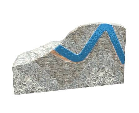
rare
Overflow Spring
A spring is a result of water collected underground in permeable material that emerges on the surface. The surface is supplied with water through precipitation, which seeps into the soil and saturates the materials below. The release of the spring on the surface is determined by the geological characteristics of the area. When clay deposits or other impervious layers support a layer of saturated material, a spring will form on the side where the impermeable layer is exposed. Similarly, springs can be found along faults as underground water reaches the surface alongside the fault plane. Springs are a valuable source of water, and their flow potential can be increased by installing a pipe at the point where water saturates the earth.
Abrir experiencia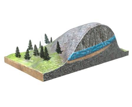
rare
Contact Spring
Contact springs made of copper beryllium (CuBe) This is characterized by its high conductivity and strength as well as its excellent spring properties. The material is also self-cleaning and resistant to air, ozone, solvents and UV light. It can even withstand nuclear radiation.
Abrir experiencia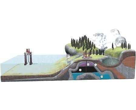
rare
Petroleum Reservoir
Oil and gas are formed from organic material mainly deposited as sediments on the seabed and then broken down and transformed over millions of years. If there is a suitable combination of source rock, reservoir rock, cap rock and a trap in an area, recoverable oil and gas deposits may be discovered there.
Abrir experiencia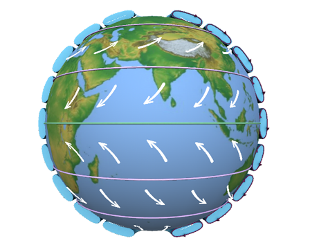
epic
Types of Wind
Wind takes on various forms, driven by Earth's rotation and local conditions. Prevailing winds are dominant and steady, like trade winds near the equator and westerlies in mid-latitudes. Polar easterlies blow from the poles. Localized winds, such as sea and land breezes, emerge due to land-sea temperature differences. Mountain-valley breezes flow up during the day and down at night. Stormy gusts bring rapid changes in direction and speed, demanding careful monitoring for safety. Understanding these wind types aids meteorologists, sailors, pilots, and planners.
Abrir experiencia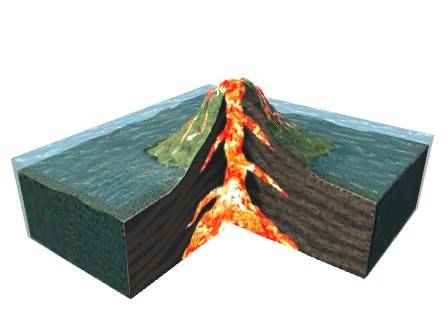
rare
Creation of Coral Atoll
This circular type of coral reef, called an atoll, is created as a ring of coral surrounds an undersea volcano that has risen above the water's surface. Long after the volcano has receded into the ocean, the atoll remains. The habitat inside the atoll, protected from the open sea by the sturdy reef, is called a lagoon.
Abrir experiencia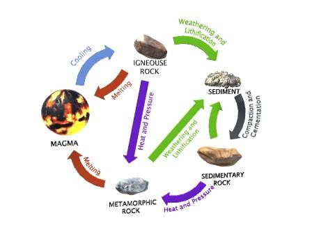
rare
Rock Cycle
The Rock Cycle is a group of changes. Igneous rock can change into sedimentary rock or into metamorphic rock. Sedimentary rock can change into metamorphic rock or into igneous rock. Metamorphic rock can change into igneous or sedimentary rock. Igneous rock forms when magma cools and makes crystals.
Abrir experiencia
rare
Earth’s atmosphere
Planet Earth is surrounded by a layer of gases called the atmosphere. These create an essential blanket for life on Earth, keeping the planet at a comfortable temperature and protecting the surface from the Sun’s rays. Earth’s atmosphere is made up of several distinct layers. There is no clear boundary to the outer edge of the atmosphere—it just fades into space. The lowest layer, called the troposphere, forms the air we breathe. The air consists mainly of two gases—nitrogen (78 percent) and and oxygen (21 percent).
Abrir experiencia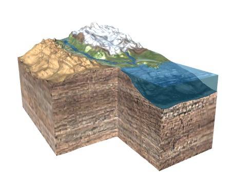
rare
How are sedimentary rocks formed
Sedimentary rocks form on or near Earth’s surface. Eroded particles of rock are transported by wind, water, and ice and deposited on dry land, on the beds of rivers and lakes, or in the seas. Over years, these pieces of rock, or sediments, are pressed together by the weight of new deposits on top of them and cement together to form rocks.
Abrir experiencia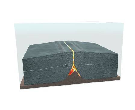
rare
Divergent (Constructive) Boundary
A divergent boundary, or constructive boundary, is where two sections of the eggshell - two tectonic plates - are moving away from each other. When this happens, they leave a gap in-between, and this gap can be filled by the magma from below. This creates a series of volcanoes all the way along the boundary.
Abrir experiencia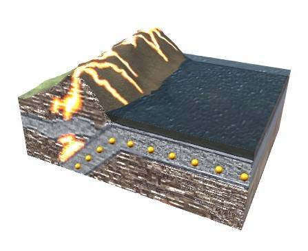
rare
Convergent (Destructive) Boundary
A convergent boundary (also known as a destructive boundary) is an area on Earth where two or more lithospheric plates collide. One plate eventually slides beneath the other, a process known as subduction. The subduction zone can be defined by a plane where many earthquakes occur, called the Wadati–Benioff zone.
Abrir experiencia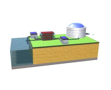
common
Desalt saline water
Desalination is the process by which the dissolved mineral salts in water are removed. Currently, this process, applied to seawater, is one of the most used to obtain fresh water for human consumption or agricultural purposes.
Abrir experiencia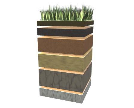
rare
Layers Of Soil
The soil is the topmost layer of the earth’s crust consisting of air, water, inorganic minerals (rock, sand, clay, and slit), and organic matter (dead plants and animals). It forms the source of food for plants. It provides shelter for many animals such as insects, centipedes, burrowing animals, microorganisms, and many others. It is thus also called the ‘skin of the earth.’ There are different soil types, each having unique characteristics like color, texture, structure, thickness, mineral content, and organic matter.
Abrir experiencia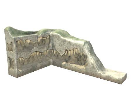
rare
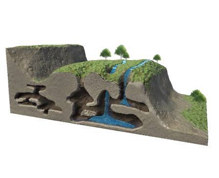
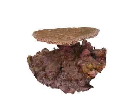
Caves
Caves are large, natural holes beneath the surface of the earth. Underground passages and caves are found in rocky landscapes across the world. They are found in areas with a lot of limestone, a common type of rock. They can be created in various ways, but most caves are hollowed out of rock by water. Water seeps through the ground and forms holes below the surface. Water that is loaded with stones grinds away the rock like sandpaper, or acidic rainwater eats away at the rock. Some early people used caves to shelter from the weather or to hide from wild animals. Some of these early people made cave paintings.
Abrir experiencia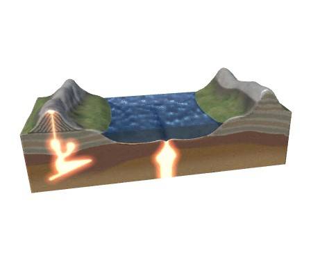
rare
Tectonic Plates
Earth’s surface appears to be still, but it is actually constantly on the move. Its outer shell is made up of huge slabs of moving rock called tectonic plates. The plates fit together like puzzle pieces to make up Earth’s surface. Their movements change the planet’s features, depending on how the plates meet. Some plates are crunching together, and may form mountains. Others are splitting apart. When this occurs under the ocean, it creates new ocean floor. Some plates grind past each other. These are the most likely to cause earthquakes.
Abrir experiencia
rare
How are metamorphic rocks formed
Metamorphic rocks form when rocks are subjected to high heat, high pressure, hot mineral-rich fluids or, more commonly, some combination of these factors. Conditions like these are found deep within the Earth or where tectonic plates meet.
Abrir experiencia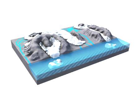
rare
Types of glacier
There are several types of glacier, based on their shape, where they are, or where they come from. The biggest types of glacier are called continental ice sheets and ice caps. They often totally cover mountains. Glaciers that flow down a valley are called valley glaciers. Outlet glaciers are valley glaciers that flow out from an ice cap or an ice sheet. When glaciers flow into flat, lowland areas, the ice spreads out to form piedmont glaciers. Glaciers that flow directly to the sea are called tidewater glaciers. The ends of these glaciers break off to form icebergs. This model shows some of the different types of glacier.
Abrir experiencia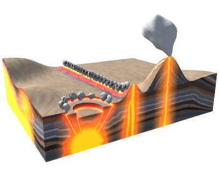
rare
How are Igneous rocks formed
Igneous rocks form when hot, liquid magma from inside the Earth cools and becomes solid. When this happens below ground, the rocks are called intrusive. When magma comes to the surface as lava and cools above ground, the rocks are called extrusive.
Abrir experiencia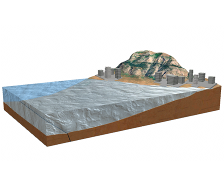
rare
Earthquake and Tsunami
By far, the most destructive tsunamis are generated from large, shallow earthquakes with an epicenter or fault line near or on the ocean floor. These usually occur in regions of the earth characterized by tectonic subduction along tectonic plate boundaries. The high seismicity of such regions is caused by the collision of tectonic plates. When these plates move past each other, they cause large earthquakes, which tilt, offset, or displace large areas of the ocean floor from a few kilometers to as much as a 1,000 km or more.
Abrir experiencia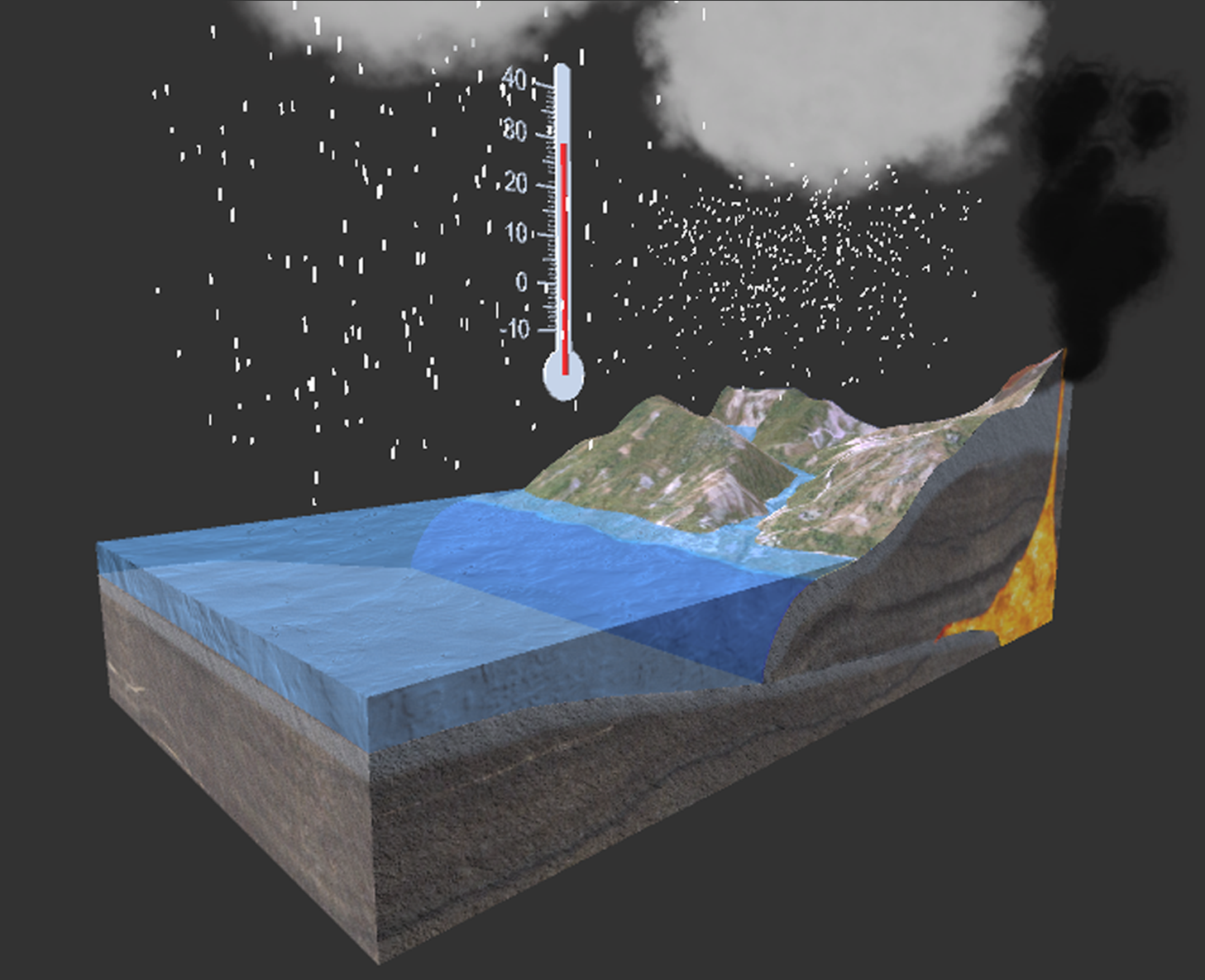
rare
Climate changes- volcanic activity
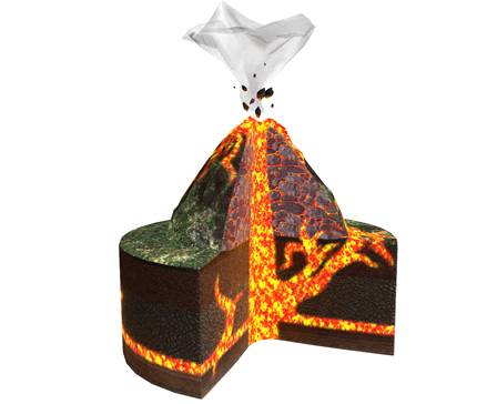
Volcanoes are unstable weak points in the Earth’s upper layer of rock. They form when chambers of magma boil to the surface. It takes a lot of heat and pressure to force molten rock to the surface, which means an eruption can take thousands of years to develop. When the volcano can no longer contain the pressure, it bursts open, sending billows of toxic fumes into the air and lava onto the surface. The smallest eruptions are negligible, but the greatest ones cause widespread damage. Volcanic eruptions are often discussed in relation to climate change because they release CO2 (and other gases) into our atmosphere.
Abrir experiencia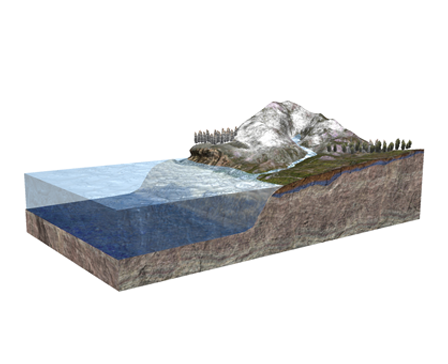
rare
Water distribution on Earth
About 71 percent of the Earth's surface is water-covered, and the oceans hold about 96.5 percent of all Earth's water. Water also exists in the air as water vapor, in rivers and lakes, in icecaps and glaciers, in the ground as soil moisture and in aquifers, and even in human beings and animals. This model shows the water distribution on Earth.
Abrir experiencia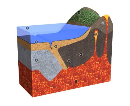
rare
Section of the Earth's Crust
The crust, Earth's outer layer, has Continental Crust (thick, land-based, with granite-like rocks) and Oceanic Crust (thin, ocean-based, with denser rocks). They meet at plate boundaries. Divergent boundaries create new crust, convergent boundaries form mountains or trenches, and transform boundaries cause earthquakes. Studying these unveils Earth's history and explains geological events.
Abrir experiencia
ARLOOPA Studio
Crea tu propia experiencia AR
Usa ARLOOPA Studio para crear y publicar una experiencia similar para tu campaña, espacio, producto o audiencia.


